SEATTLE — Widespread thunderstorms are possible across western Washington Wednesday afternoon into the night, thanks to an unstable air mass moving across the region.
The National Weather Service (NWS) has issued a Severe Thunderstorm Watch for King County and southward counties into Oregon, which expires at 9 p.m. Wednesday night. Impacted counties in Washington include King, Pierce, Lewis, Thurston, Clark, Cowlitz and Skamania.
Though not as high as Tuesday’s temperatures, Wednesday is expected to be unseasonably warm with high temperatures in the 60s. According to the NWS, at this same time, a cold front is moving in over Washington. This creates the ideal conditions for potential thunderstorms.
The NWS forecasted that an air mass above western Washington will remain moist and unstable, leading to the risk of thunderstorms, hail, wind, cloud-to-ground lightning and periods of heavy rainfall. There is a “slight chance” of severe weather across the region, with a chance for isolated, severe storms from Snohomish County southward along the I-5 corridor and parts of the peninsula.


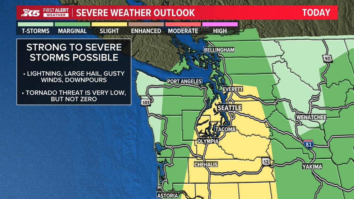
Storms are anticipated to hit the Seattle metro area and southward between 5 p.m. and 7 p.m. Areas north of that can expect to see storms between 7 and 9 p.m.
The greatest concerns related to this weather system will be lightning and large hail. There’s a 15-29% chance of severe hail (greater than one inch in diameter) from Everett south along the I-5 corridor into Oregon, according to the weather service. There is a 10% chance of hail two inches in diameter in the same area. Elsewhere has an approximate 5% chance of hail at least one inch in diameter. There’s up to a 14% chance for severe wind gusts (greater than 58 miles per hour) in much of western Washington.
There’s a 2-4% chance of a tornado along the I-5 corridor, according to the weather service.


According to the National Oceanic and Atmospheric Administration (NOAA), thunderstorms need three “basic ingredients” to form, all of which will be present Wednesday in western Washington.

Moisture needs to be present, air needs to be unstable and rising, and something needs to nudge the air upward toward the clouds.
Higher than normal surface temperatures raise the warm air that’s lower to the ground up into the atmosphere, carrying water vapor that begins to cool as the air rises.
The air will continue to rise as long as it weighs less and stays warmer than the air around it, according to the NOAA.
As the water vapor condenses, the air and the water vapor form a cloud, which eventually rises into areas where the temperature is below freezing. The water particles will become particles of ice. When two ice particles collide, one particle can rip off “a little bit of ice” from the other one, and take with it some electric charge. As these collisions occur more frequently, large regions of electric charges build up to cause a bolt of lightning, which creates the sound we know as thunder.