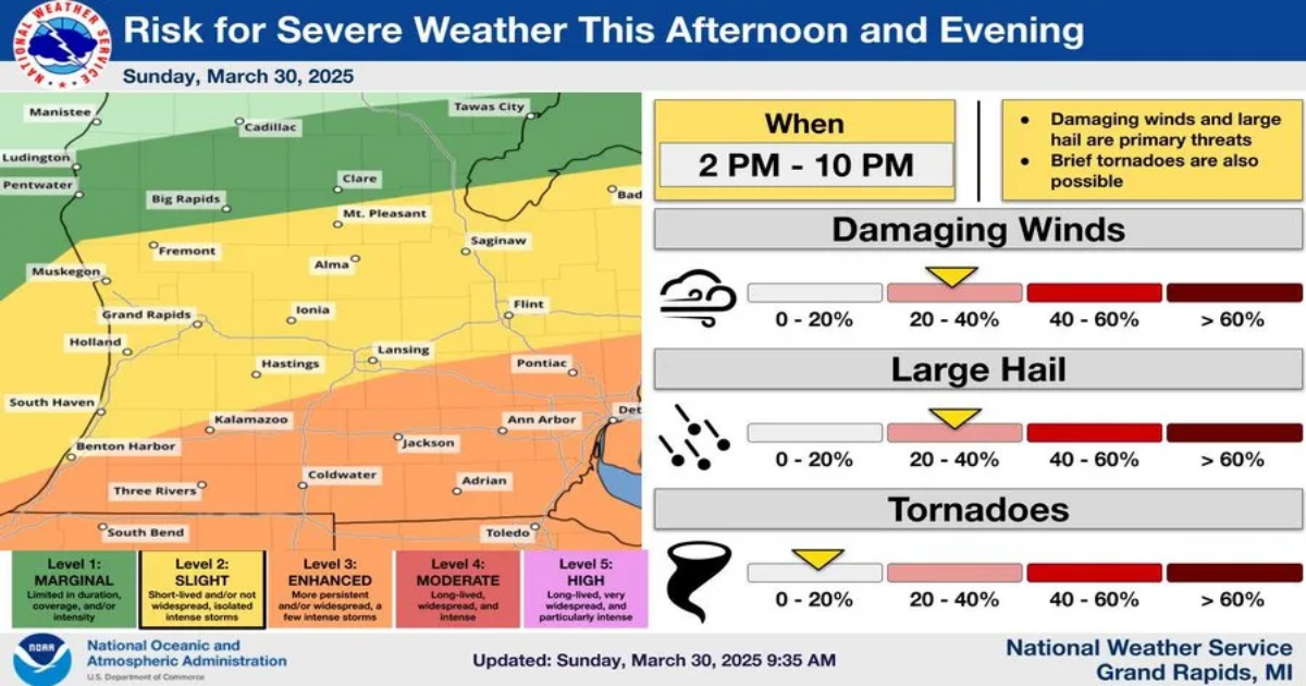
- The Lansing region could experience severe storms Sunday, with damaging winds, large hail, and a slight chance of a tornado.
- The most severe weather is expected south of M-46, with Lansing at a slight risk and areas further south at an enhanced risk.
- Temperatures are expected to reach near 70 degrees Sunday before dropping to a low of 36 degrees overnight.
UPDATED 7:45 P.M. – All warnings in the Lansing area have expired.
UPDATED 6:30 P.M. – A tornado warning has been issued in the Lansing area by the National Weather Service until 7:15 p.m. Sunday evening. People are urged to take cover and go to a basement if one is available. Holt, Mason and Michigan State University are included in the warning.
UPDATED 6:13 P.M. – The National Weather Service in Grand Rapids has issued a severe thunderstorm warning for the Lansing area and Jackson, Ingham, Gratiot, Clinton and Eaton counties until 7:30 p.m. Sunday.
The warning, issued at 5:56 p.m., warns area residents that winds up to 70 mph can be expected as strong storms move across Southwest and West Michigan into the region.

Check back for updates.
ORIGINAL STORY:
LANSING – The National Weather Service has issued a severe thunderstorm watch for much of Lower Michigan.
The National Weather Service Grand Rapids station issued a severe thunderstorm watch Sunday afternoon for a wide area of lower Michigan, including Lansing and the surrounding region. It includes Ingham, Eaton, Clinton, Ionia and Calhoun counties as well as others west toward Lake Michigan and is in effect until 9 p.m. Sunday.

“We expect a line of thunderstorms to move through the area (between 3 p.m and 9 p.m. ) racing northeast near 50 mph. All hazard types are possible today with damaging winds in excess of 60 mph being the main threat,” the weather service said in its alert. “Hail larger than one inch will be possible with the strongest storms. Isolated tornadoes cannot be ruled out today either. Locally heavy rain can be anticipated briefing as the storms race through.”
The weather service had earlier issued a hazardous weather outlookk warning of damaging winds and large hail and raised the possibility of isolated tornadoes.
The weather service had said severe thunderstorms were possible between 2 p.m. and 10 p.m. Sunday across much of lower Michigan, “with the best chance of severe weather south of M46,” or a line roughly from Newago in West Michigan to Alma and further east to Saginaw.
MORE: Power outages sweep across Northern Michigan due to ice storm

While Lansing was in a slight risk category for storms under the hazardous weather outlook, areas south of the capital city, including Mason and much of southern Ingham County as well as Jackson and areas south into northern Ohio, were in an enhanched risk category, with a higher chance of severe weather.
Temperatures are expected to reach 67 degrees Sunday in breezy conditions. There is an 80% chance of rain throughout the day with winds up to 25 miles per hour.
Sunday evening, there are chances of thunderstorms before 2 a.m. and winds are expected to gust to 32 mph while temperatures drop more than 30 degrees to a low of 36.
Monday’s high is forecast at 42 degrees with gusts as high as 24 mph before sunny skies return Tuesday.