Snow chances into Valentine’s Day weekend for Omaha area
 Updated: 8:42 PM CST Feb 14, 2025
SANDWICHES ARE DELICIOUS. IT’S TASTY. YEAH. ALL RIGHT, WELL, WE UPGRADED TOMORROW TO A SEVERE WINTER WEATHER KIND OF TIME FRAME THERE. GOING OVERNIGHT AND INTO TOMORROW MORNING. THE BIG QUESTION FOR US IS JUST WHERE A NARROW BAND OF SNOW LINES UP. AND THAT’S WHERE THE MAJORITY OF THE IMPACTS ARE GOING TO BE. SO I DON’T THINK EVERYONE HERE IS GETTING A LOT OF SNOW. I DON’T THINK EVERYONE IS GETTING A LOT OF FREEZING DRIZZLE, BUT SOME PEOPLE WILL AND WE’RE GOING TO OUTLINE THAT FOR YOU. BUT AT LEAST THE WINTER WEATHER ADVISORY GOES FROM MIDNIGHT TILL 6:00. I THINK THE TIME FRAME FOR OMAHA WHEN YOU COULD GET PRECIPITATION WOULD BE MIDNIGHT TILL 1:00, AND THAT COULD BE A MIX OF BOTH A LITTLE BIT OF A FREEZING DRIZZLE AND SNOWFALL. LET’S TIME IT OUT. STORM PREDICTOR HERE. JUST CLOUDY FOR YOUR VALENTINE’S DAY EVENING. NO ISSUES. IF YOU’RE OUT PAST MAYBE 10:00, THAT’S WHEN YOU COULD SEE A LITTLE BIT OF PRECIPITATION. TEMPERATURES WILL BE BELOW FREEZING AT THAT TIME, AND THERE COULD BE A LITTLE WARM POCKET OF AIR JUST ABOVE THE SURFACE. BUT NOTICE THESE TEMPERATURES HERE AT THE GROUND BELOW FREEZING. SO THAT’S WHY WE THINK IT’S POSSIBLE FOR FREEZING DRIZZLE ON ANY SURFACES THAT ARE UNTREATED. THIS IS MIDNIGHT RIGHT HERE NORTH OF I-80. LOOKS MORE LIKE SNOW. AND THEN THE HEAVY BAND OF SNOW LINING UP, MAYBE NEAR TEKAMAH TEKAMAH. EXCUSE ME, THROUGH DODGE COUNTY AND OFF TO THE WEST, AND THEN MORE FILLING IN WITH SNOW OR FREEZING DRIZZLE IN THE EARLY MORNING HOURS. AND THIS WILL EXIT OFF TO THE EAST, PROBABLY EVEN BEFORE NOON. SO LET’S SHOW YOU TWO COMPUTER MODELS HERE. HERE’S THE COMPUTER MODEL WE JUST SHOWED YOU. AND THIS IS SHOWING ACCUMULATED SNOW. TEKAMAH DODGE COUNTY. THOSE ARE THE AREAS WHERE THAT NARROW BAND COULD LINE UP. LET’S SHOW YOU A SECOND COMPUTER MODEL HERE JUST TO SHOW YOU WHAT WE’RE SEEING AS WELL. THIS IS SHOWING THAT NARROW BAND OF SNOW CLOSER TO OMAHA. THE OTHER COMPUTER MODEL DIDN’T EVEN GIVE AN INCH FOR OMAHA. THIS ONE CLOSE TO FOUR INCHES. SO THERE IS SOME UNCERTAINTY HERE. BUT THE MAIN THING IS JUST THE DARKER BLUE SHADE. WHERE DOES THAT NARROW BAND LINED UP? YOU COULD GET 3 TO 6IN IN THERE. OUTSIDE OF THAT, THE LIGHTER BLUE YOU’RE PROBABLY DESCENDING INTO THE 1 TO 2, MAYBE THREE INCH RANGE. AND THEN OUTSIDE OF THERE, THE WHITE, A TRACE TO AN INCH. AND THEN WE ALSO HAVE TO ACCOUNT FOR ANY ICE THAT WE COULD GET, WHICH WOULD BE THE FREEZING DRIZZLE. IT WON’T BE MUCH, BUT IF YOU SEE IT, IT’S PROBABLY SOUTH OF I-80. BUT AGAIN, THE ROADS ARE WELL TREATED. YOU NEED AN UNTREATED SURFACE TO THAT FOR THAT TO REALLY FREEZE. 33 DEGREES. THE WINDS OUT OF THE SOUTH 22MPH. WE KNOW WHAT THAT BRINGS. A WIND CHILL AND THE WIND CHILLS ARE IN THE LOWER 20S. ACTUAL AIR TEMPERATURES ABOVE FREEZING FOR MOST OF US, HOUR BY HOUR FORECAST FOR THE REST OF THE AFTERNOON THROUGH VALENTINE’S EVENING. LOOKS GOOD. IF YOU’RE GOING TO THE MOVIES, YOU HAVE DINNER PLANS. I WOULDN’T WORRY ABOUT IT. JUST KNOW IT’S GOING TO BE BREEZY, SO YOU MIGHT WANT SOME LAYERS OR THE THICKER JACKET OUT THE DOOR. TOMORROW’S 12 HOUR FORECAST. WE’RE GOING TO GO. SEVERE WEATHER IMPACTS FOR MOST OF THE OVERNIGHT HOURS THROUGH ABOUT 10 OR 11:00. AFTER THAT, I THINK YOUR DAY IS PRETTY MUCH OKAY. AND THEN THERE’S JUST CLOUDS AND A STRONG WIND, BUT TEMPERATURES WILL BE DESCENDING IN THE AFTERNOON. IT’S KIND OF AN INTERESTING DAY. WE’LL START NEAR 27. WE’LL ACTUALLY END THE DAY, MAYBE EVEN IN THE TEENS. SUNDAY, MONDAY TEMPERATURES REALLY START TO DESCEND. THERE’S ANOTHER SNOW CHANCE ON MONDAY THAT WE’RE GOING TO HAVE TO WATCH FOR. AND IT LOOKS LIKE WE’RE WE’RE GOING TO GET THAT. IT MAY NOT BE A TON OF SNOW, BUT IT LOOKS LIKE WE’RE AT LEAST GOING TO GET SOMETHING ON MONDAY, TUESDAY, WEDNESDAY. WE’VE UPGRADED TO SEVERE WEATHER DAYS AS WELL. THAT’S JUST FOR THE COLD. DOUBLE DIGITS BELOW ZERO TUESDAY, WEDNESDAY AND THURSDAY MORNING AND FRIDAY’S NOT FAR OFF HERE. SO IT’S A VERY IMPACT. WEATHER SEVEN DAY FORECAST. AND IT IS SO TRICKY TO FORECAST WHEN YOU GOT THAT NARROW BAND OF SNOW BECAUSE YOU GO FIVE MILES THIS WAY, FIVE MILES THIS WAY. IT’S IT’S A
We have flipped the switch on winter this week in Omaha after picking up more snow on Wednesday alone than the previous five months combined. With the combination of brutal cold and additional snow chances, Omaha’s Weather Leader has deemed each day through the weekend impact weather days. A winter weather advisory has been issued from 9 p.m. to 6 p.m. on Saturday.Track the weather wherever you are with our Interactive RadarAnother round of snow is likely late Friday night into Saturday morning so any Valentine’s Day evening plans should remain snow free for the most part. An additional 1 to 3 inches of snow is likely by noon Saturday. A band of heavy snow is possible that could generate a narrow swath of 3 to 6 inches. As of 9 p.m. on Friday, that band will travel through the Tekamah area. It is possible that band could line up near the metro. 10 to 20 miles could make a big difference in how much snow we’ll get.Brutal cold returns Saturday night and Sunday with wind chill values expected to drop down 10 to 20 degrees below zero by Sunday morning.Stay up to date with the latest impact weather forecast by downloading the KETV mobile app.NAVIGATE: Home | Weather | Local News | National | Sports | Newscasts on demand |

We have flipped the switch on winter this week in Omaha after picking up more snow on Wednesday alone than the previous five months combined.
With the combination of brutal cold and additional snow chances, Omaha’s Weather Leader has deemed each day through the weekend impact weather days.
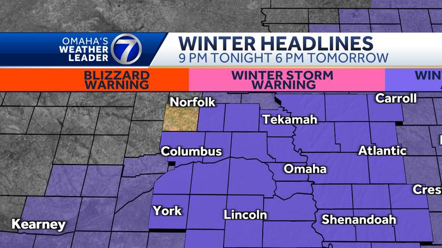
A winter weather advisory has been issued from 9 p.m. to 6 p.m. on Saturday.

Track the weather wherever you are with our Interactive Radar

Another round of snow is likely late Friday night into Saturday morning so any Valentine’s Day evening plans should remain snow free for the most part. An additional 1 to 3 inches of snow is likely by noon Saturday. A band of heavy snow is possible that could generate a narrow swath of 3 to 6 inches. As of 9 p.m. on Friday, that band will travel through the Tekamah area. It is possible that band could line up near the metro. 10 to 20 miles could make a big difference in how much snow we’ll get.

Brutal cold returns Saturday night and Sunday with wind chill values expected to drop down 10 to 20 degrees below zero by Sunday morning.
Stay up to date with the latest impact weather forecast by downloading the KETV mobile app.
NAVIGATE: Home | Weather | Local News | National | Sports | Newscasts on demand |